Distance Help
How do you figure out the distance between two points on a map?
When I wrote the Glacier Gorge example, I used a mapping program to determine the distance between the Dream Lake trail and Half Mountain. If you don't have a mapping program, the next best option is to use a paper map and a ruler.
First measure the distance between two points on the map. Here we get a measurement of 48 millimeters.
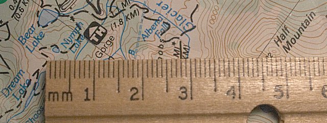
Next, measure the length of the distance scale on the map. Measure the whole thing, not just one mile. Measuring the whole thing helps to improve accuracy. Here we get a measurement of 53 millimeters.

Next calculate. 48 / 53 x 2 x 5280 = 9563 feet. That's pretty close to the number I got with my mapping program. You'll notice that I measured the distance on the map in millimeters rather than inches. That's
okay because when you divide 48 millimeters by 53 millimeters, the millimeters part cancels and drops out of the
equation. Besides, if we used inches, we'd have to deal with those messy fractions. The "times 2" is in
there because we measured the length of two miles on the distance scale rather than just one. If the distance
scale on your map is three miles, then measure the whole three miles and change the "2" in the equation to a
"3". The breakdown of the calculation works like this:
48 millimeters / 53 millimeters = 0.9057
0.9057 x 2 = 1.811 miles
1.811 miles x 5280 feet per mile = 9563 feet
Return to
Moon Position Help.