Grand Canyon - Rim To Rim
A Preview Of The Hike

This page is a small preview of a hike that I and a few others will make later this year in the Grand Canyon. It was initially intended as a simple means for me to share some of the unique information I had with the other participants of the hike. Namely 3D maps, route profiles, etc. As others stumble onto this page and become interested, I caution that this is a difficult hike not to be taken lightly. Without proper preparation, physical conditioning and timing, it can actually be deadly. Heat and availability of water are major concerns.
The Big Picture
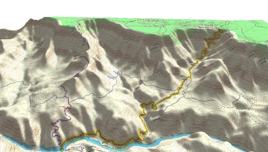
 Click this map to get a larger version of the whole rim to rim route. North of the river is the North Kaibab trail. South of the river are two possible routes. The west route is the Bright Angel trail which follows a drainage. The east route is the South Kaibab trail, which follows a ridge.
 Click this picture for a good overview of where the trails are on a photo of the area.
 I found this photo of the area on www.kaibab.org. It is much clearer than my photo and taken from Yavapai Point looking NNE in the direction of the Bright Angel Canyon. Yavapai Point is about half way between the Bright Angel trailhead and the South Kaibab trailhead. The Garden Creek Drainage (and Bright Angel Trail) is out of view to the west. The South Kaibab trail is atop the near ridge at the right edge of the photo.
Day 1 - Hike to Phantom Ranch
 Route profile of the North Kaibab trail. Actual distance is closer to 14 miles. It's just not possible to add all the switchbacks in to the total distance.
 Looking north, the north rim starting point is at the top of the map. Phantom Ranch is just north of the river at the bottom of the map.
Notable sites along the way. (Other than what you find on the map.)
Roaring Springs Cave -- Exploration of the Roaring Springs Cave in Grand Canyon National Park. 1934
Day 2 - Hike Inner Canyon
 Here are the major prospects for hikes in the inner canyon. Green is the Clear Creek Trail. Red is the Tonto Trail which follows the river atop the Tonto Platform for as far as you want to go. Gray goes to Plateau Point. Or we could just say "screw it" and head for the beer hall.

![]() This link will take you to a topo map of the Phantom Ranch area. Once there, you can move in any direction you want.
This link will take you to a topo map of the Phantom Ranch area. Once there, you can move in any direction you want.
Day 3 - Hike to South Rim
We have two choices here; the South Kaibab trail, or the Bright Angel trail.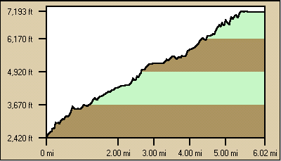

Choice 1: South Kaibab. Actual distance of the South Kaibab trail is closer to 6.7 miles. Looking south, the trail follows a ridge.

Choice 2: Bright Angel. Actual distance of the Bright Angel trail is closer to 9.5 miles. Looking south, the trail follows a drainage.
Notes
 I remember the Horseshoe Mesa trail as being pretty steep in some areas. So naturally I wondered how the steepness of that trail compared with the Rim to Rim trails. To make the comparison, I took all my route profiles and scaled them to the same scale in both elevation gain and length. Then I overlayed them all and ended up with an excellent visual comparison of the relative steepness of each trail.
Hike Report Links
Here are some hike reports from others who have done this hike.
North Rim to South Rim -- Nice narrative.
Rim to Rim In One Day -- Night hike.
Weather
Someone mentioned in Yahoo Groups - Grand Canyon that the high temperature at Phantom Ranch during the summer is often about the same as the high in Phoenix. Usually within 5 degrees.


All maps and most route profiles on this page built with: DeLorme Topo USA