


The hike to Lake Dorothy starts from the same trailhead as my previous day's hike to Diamond Lake, the Buckingham trailhead near the Fourth Of July campsite. So I got to drive that five mile long, narrow, dusty, rough road again. But boy was it worth it! It was another great hike with perfect weather.
Be sure to click on these thumbnail photos for larger versions.
 |
1. Right off the bat, a splash of color to start the hike. |
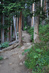 |
2. Then into the woods we go. |
 |
3. Early in the morning, the trail is still in shade and the nearby trees look silhouetted against the sunlit distant mountains. Mount Jasper is the far peak at center, Mount Neva is the far peak at the right. |
 |
4. Blue Columbine. |
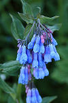 |
5. Chiming Bells. |
 |
6. The pointy peak at center is Mount Neva. Lake Dorothy is just below Mount Neva, to its right. |
 |
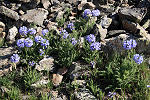
7. Purple Fringe. |
 |
8. Blue Columbine. |
 |
9. Hikers on the trail. |
 |
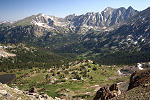
10. Looking back, down the North Fork Middle Boulder Creek valley. |
 |
11. Arapaho Pass is up ahead. I'll stop there first then head up to Lake Dorothy. That's Mount Neva to the left. |
 |
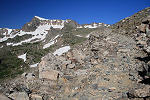
12. This peak doesn't have a name. It's just part of the ridge that makes up the Continental Divide. |
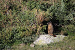 |
13. A marmot. Looks like he's guarding a cave. |
 |
14. The tip of Mount Jasper is just barely visible over some closer stuff. |
 |
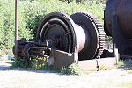
15. Some of the equipment is still at the site of the old Fourth of July Mine. This looks like a horse powered winch to me. You bolt a long plank in that U shaped bracket on top, tether a horse to the end of the plank, then the horse walks in circles around the winch. |
 |
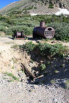
16. They must have gotten tired of using horses and switched to steam power. All the little holes in the end of the tank are the ends of flue pipes that run through the water tank. The fire box is at the other end. The hot gasses from the fire run through the flue pipes, heating the water, then up a smoke stack. |
 |
17. There seems to be some stuff missing here like a crankshaft and flywheel. |
 |
18. Man, how did they haul all this stuff up here? This stuff looks heavy. |
 |
19. And how did they decide to dig right there? |
 |
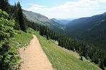
20. Once you get above treeline, there is a long stretch of trail with wide open views. Super Size It! (431kB). |
 |
21. Sky Pilot. (Thanks steph.) |
 |
22. Here is a closer picture. |
 |
23. You can't see it in this picture, but Diamond Lake is off in that direction. |
 |
24. The trail and Mount Neva. |
 |
25. Looking back at the trail I've been following. |
 |
26. That's Mount Neva. I'm getting close to Arapaho Pass now. |
 |
27. I've reached Arapaho Pass now and looking across to the west side. Some of the peaks here are Mount Achonee, Mount George, Apache Peak and Navajo Peak. |
 |
28. Looking down more, you can see the trail coming up from the west side. Look at the switchbacks. |
 |
29. Now I'm heading up toward Lake Dorothy and looking back at Arapaho Pass. |
 |
30. A panoramic view of the west side over Arapaho Pass. Super Size It! (408kB). |
 |
31. There it is! Lake Dorothy. That's Mount Neva in the back and a rock shelter in the foreground. |
 |
33. There are tracks all over the snow that look like ski trails. Could it be? They're pretty hard to see in this picture though. |
 |
34. Zooming in a little. |
 |
35. I climbed up the ridge to the southeast of the lake a little to explore. |
 |
36. Looking southeast. |
 |
37. Looking over Arapaho Pass toward the Arapaho Peaks. |
 |
38. Another look at Arapaho Pass. |
 |
39. And finally, another look at Lake Dorothy before I depart. |
